Ternate adalah salah satu pulau yang terletak di sebelah barat pantai Halmahera dan merupakan salah satu dari deretan pulau-pulau vulkanis yang masih aktif Luas wilayah keseluruhannya adalah 5.681,30 Km2.
Kotamadya Ternate berbatasan dengan ;
· Sebelah utara dengan Samudera Pasifik dan perairan selatan negara Filipina
· Sebelah selatan dan barat dengan Laut Maluku
· Sebelah timur dengan pantai barat Halmahera
Selain itu, letak pulau Ternate adalah dekat dengan kota Manado ibukota Propinsi Sulawesi Utara. Posisi strategis yang berhadapan dengan kawasan Dodinga, sebuah persimpangan jalan di pulau Halmahera yang menyebabkan kota ini berkembang dalam lajur perdagangan di daerah Maluku Utara.
Geografi ;
Luas Kotamadya Ternate sekarang berdasarkan UU No.11 thn 1999 tersebut adalah 5681,30 Km2, terdiri dari;
Wilayah Perairan : 5.457,55 Km2
Wilayah Daratan : 133,74 Km2
Wilayah daratan mencakup 8 buah pulau, yaitu;
· Pulau Ternate : 92,12 Km2
· Pulau Hiri : 7,31 Km2
· Pulau Moti : 17,72 Km2
· Pulau Mayau : 8,5 Km2
· Pulau Tifure : 7 Km2
· Pulau Makka : 0,5 Km2, tidak berpenghuni
· Pulau Mano : 0,05 Km2, tidak berpenghuni
· Pulau Gurida : 0,55 Km2, tidak berpenghuni
· Pulau Ternate - Pulau Hiri : 1,5 mil laut
· Pulau Ternate - Pulau Moti : 11 mil laut
· Pulau Ternate - Pulau Mayau : 90 mil laut
· Pulau Ternate - Pulau Tifure : 106 mil laut
· Pulau Ternate - Pulau Makka : 1,6 mil laut
· Pulau Ternate - Pulau Mano : 1,6 mil laut
· Pulau Ternate - Pulau Gurida : 106,1 mil laut
Pulau-pulau dalam wilayah Kotamadya Ternate terletak dalam lingkup kawasan pantai barat pulau Halmahera, melalui kepulauan Filipina, Sangihe Talaud dan Minahasa yang dilingkupi lengkung Sulawsi bagian utara. Wilayah Kotamadya Ternate terletak antara 1270 Bujur Timur dan 1270 Bujur Barat serta 30 – 3 0 Lintang Selatan.
Kotamadya Ternate berbatasan dengan ;
· Sebelah utara dengan Samudera Pasifik dan perairan selatan negara Filipina
· Sebelah selatan dan barat dengan Laut Maluku
· Sebelah timur dengan pantai barat Halmahera
Pulau Ternate berbentuk bulat kerucut/strato volcano.
Topografi ;
Ciri Topografi sebahagian besar dataran bergunung dan daerah berbukit, terdiri dari pulau vulkanis dan pulau karang dengan kondisi jenis tanah :
· Rogusal : Pulau Ternate, pulau Hiri dan pulau Moti
· Rensikal : Pulau Mayau, pulau Tifure, pulau Makka, pulau Mano dan pulau Gurida
Kotamadya Ternate beribukota di Kota Ternate yang berada di pulau Ternate, memiliki 3 (tiga) kecamatan, 23 kelurahan dan 33 desa, yakni :
· Kecamatan Kota Ternate Utara, 13 Kelurahan, 4 Desa
· Kecamatan Kota Ternate Selatan, 10 Kelurahan, 9 Desa
· Kecamatan Pulau Ternate, 22 Desa
Ekonomi ;
Kedudukan kota Ternate adalah sebagai pusat pemerintahan dan pusat perdagangan yang sangat strategis dan penting sekali di kawasan ini. Do Kota Ternate terdapat Pelabuhan Samudera “Ahmad Yani” dan Bandar Udara “Babullah”. Kota Ternate itu sendiri berlokasi di pesisir timur pulau Ternate menghadap pulau Halmahera posisi ini sangat potensial. Kedudukan yang demikian ini menyebabkan kota Ternate memiliki peranan yang sangat penting dalam ekonomi perdagangan lintas Halmahera.
Selain itu, letak pulau Ternate adalah dekat dengan kota Manado ibukota Propinsi Sulawesi Utara. Posisi strategis yang berhadapan dengan kawasan Dodinga, sebuah persimpangan jalan di pulau Halmahera yang menyebabkan kota ini berkembang dalam lajur perdagangan di daerah Maluku Utara.
Penduduk ;
Perkembangan penduduk Kotamadya Ternate selama lima tahun terakhir mengalami kecenderungan peningkatan khususnya di wilayah kecamatan Kota Ternate Selatan dan kecamatan Kota Ternate Utara.
Peningkatan ini disebabkan faktor urbanisasi, migrasi maupun dari kawasan pulau Halmahera akibat konflik etnis beberapa waktu yang lalu, dan migrasi dari regional lain dari Sulawesi, Ambon, Papua bahkan dari Kalimantan, Jawa dan Sumatera.
Meningkatnya arus urbanisasi dan migrasi juga disebabkan oleh semakin terbukanya arus transportasi laut yang menghubungkan kota Ternate dengan kawasan sekitarnya dan beberapa kota lainnya.
Berdasarkan registrasi penduduk Kotamadya Ternate pada akhir desember 1999, jumlah penduduk sebanyak 115.787 jiwa, terdiri dari laki-laki sebanyak 57.886 jiwa dan perempuan 57.901 jiwa. Usia kerja 76.447 jiwa. Dari usia kerja ini terdapat usia kerja produktif 38.731 jiwa yang terbagi atas yang bekerja 31.707 jiwa dan pencari kerja 7.024 jiwa.
Kepadatan rata-rata penduduk Kotamadya Ternate sejak tahun 1999 adalah 865 Jiwa/km2, dengan laju pertumbuhan rata-rata 3% dengan kontribusi kelahiran, urbanisasi dan migrasi hampir sama yang tersebar di 3 (tiga) wilayah kecamatan yang jumlah penduduknya terbanyak, dimana tingkat kepadatan tertinggi adalah ditempati oleh kecamatan Kota Ternate Selatan, yaitu 1.637 Jiwa/km2, kemudian urutan kedua ditempati kecamatan Kota Ternate Utara dengan 1.592 Jiwa/km2, serta urutan ketiga kecamatan Pulau Ternate 246 Jiwa/km2.
Pendidikan ;
Kondisi pendidikan di Kotamadya Ternate secara umum sudah semakin membaik, walaupun harus diakui bahwa dari segi kualitas perlu terus dikembangkan karena masih jauh dibanding dengan kota–kota di wilayah pulau Jawa.
Sarana pendidikan yang tersedia mulai dari Taman Kanak-Kanak hingga tingkat Perguruan Tinggi ialah :
· Kelompk Bermain : -
· Sekolah Taman Kanak-Kanak : 48 unit
· Sekolah Dasar : 83 unit
· SLTP : 18 unit
· SMU : 15 unit
· Akademi : 2 unit
· Perguruan Tinggi : 2 unit
Sementara itu jumlah para guru/pengajar yang tersedia secara kuantitas sudah hampir memadai hanya saja untuk bidang studi tertentu perlu mandapatkan perhatian. Begitu juga dengan tenaga dosen di Perguruan Tinggi baik di UIVERSITAS KHAIRUN (Universitas Negeri Ternate) maupun STAIN serta AKPER dan AKBID telah ditingkatkan, baik dari segi kuantitas maupun kualitas dengan menempuh jenjang pendidikan S2 maupun S3.
=======================================================================
Ternate is an island located on the west coast of Halmahera and is one of a row of volcanic islands that are still active area of the total is 5681.30 km2.
Ternate Municipality borders;
• The north with the Pacific Ocean and the southern waters of the Philippines
• The south and west of the Molucca Sea
• The east with the west coast of Halmahera
In addition, the location of the island of Ternate is close to the city of North Sulawesi provincial capital Manado. Strategic position opposite the Dodinga region, a crossroads on the island of Halmahera, which caused the city is growing in the trade lanes in the area of North Maluku.
Area of Municipality of Ternate is now based on Law No.11 year 1999 is 5681.30 km2, comprising;
Aquatic Areas: 5457.55 km2
Land Area: 133.74 km2
Land area covers eight islands namely;
• Ternate Island: 92.12 Km2
• Pulau Hiri: 7.31 Km2
• Island Moti: 17.72 Km2
• Island Mayau: 8.5 Km2
• Island Tifure: 7 Km2
• Island Makka: 0.5 Km2, uninhabited
• Island Mano: 0.05 Km2, uninhabited
• Island Gurida: 0.55 Km2, uninhabited
The distance between the island;
• Ternate Island - Pulau Hiri: 1.5 nautical miles
• Ternate Island - Island Moti: 11 nautical miles
• Ternate Island - Island Mayau: 90 nautical miles
• Ternate Island - Island Tifure: 106 nautical miles
• Ternate Island - Island of Makka: 1.6 nautical miles
• Ternate Island - Island Mano: 1.6 nautical miles
• Ternate Island - Island Gurida: 106.1 nautical miles
The islands of Ternate Municipality territory lies within the scope of the west coast of Halmahera island, through the Philippine archipelago, Minahasa and Sangihe Talaud covered Sulawsi northern arch. Ternate Municipality region lies between 1270 and 1270 east longitude West longitude and 30-3 0 south latitude.
Ternate Municipality borders;
• The north with the Pacific Ocean and the southern waters of the Philippines
• The south and west of the Molucca Sea
• The east with the west coast of Halmahera
Topographic;
Cone-shaped island of Ternate / strato volcano. Characteristic Topography sebahagian large mountainous and hilly terrain, composed of volcanic islands and coral islands with the condition of soil types:
• Rogusal: the island of Ternate, Hiri island and the island of Moti
• Rensikal: Mayau Island, the island Tifure, Makka island, islands and island Gurida Mano
Administrative;
Municipality of Ternate, capital of the "Ternate" located on the island of Ternate, has 3 (three) districts, 23 villages and 33 villages, namely:
• Northern District of Ternate, 13 Village, Village 4
• Southern District of Ternate, 10 Sub, 9 Village
• District Ternate Island, 22 Village
Economical;
Status of Ternate city is the center of government and commercial center that is strategically important in the region.Do Ternate contained Harbor Ocean "Ahmad Yani" and Airport "Babullah". Ternate town itself is located on the east coast facing the island of Halmahera island of Ternate is a potential position.This position thus causing the city of Ternate has a very important role in the economy of trading across Halmahera.
In addition, the location of the island of Ternate is close to the city of North Sulawesi provincial capital Manado. Strategic position opposite the Dodinga region, a crossroads on the island of Halmahera, which caused the city is growing in the trade lanes in the area of North Maluku.
Population;
Development of the Municipality of Ternate residents over the last five years experienced an increasing trend, especially in the districts of Ternate Ternate South and North districts.
This increase is due to factors of urbanization, migration and from the island of Halmahera region due to ethnic conflict some time ago, and migration from other regional from Sulawesi, Ambon, Papua, even from Borneo, Java and Sumatra.
Increased urbanization and migration are also caused by the increasingly open flow of sea transport linking the city of Ternate with the surrounding area and several other cities.
Based on population registration Ternate Municipality in late December 1999, a population of 115,787 souls, composed of male and female soul as much as 57 886 57 901 inhabitants.76,447 working age people. Of working age have productive working age 38,731 souls, divided into working life and job seekers 31 707 7024 souls.
The average population density of Ternate Municipality since 1999 is 865 Jiwa/km2, with an average growth rate of 3% with the contribution of birth, urbanization and migration is almost the same spread in 3 (three) districts that the population majority, where the level density The highest is occupied by a district south of Ternate, which Jiwa/km2 1637, then second place is occupied districts north of Ternate city with Jiwa/km2 1592, and the third sub-246 Jiwa/km2 Ternate Island.
Education;
The condition of education in the municipality of Ternate in general is getting better, although it must be admitted that in terms of quality needs to be developed because it is still far compared with cities in the region of Java island.
Educational facilities available ranging from Kindergarten to University level are:
• Faction Playing: -
• School Kindergarten: 48 units
• Elementary School: 83 units
• Junior High School: 18 units
• High school: 15 units
• Academy: 2 units
• Higher Education: 2 units
Meanwhile the number of teachers / instructors are available in quantity almost sufficient only for the particular field of study needs to mandapatkan attention. Likewise, with lecturers at universities both in UIVERSITAS Khairun (State University of Ternate) or STAIN and AKBID Nursing Academy and has been improved, both in terms of quantity and quality of education by taking the S2 and S3.
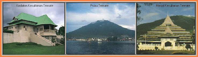
Old Ternate Palace & Old Mosque In Ternate


View of Ternate Town
Klik Tampilan Slide


Salam Maku Dero Jou Ngon Moi-Moi : " SUBA NI HADO "
Waktu di Ternate
Cari Arsip Tulisan
Buku Tamu
Translated into the languages below
Polling Blog
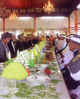
Makanan Adat
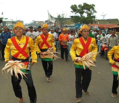
Tarian Soya=Soya
Waktu di Jakarta
kampungblog.com
Space Iklan

Penulis (Author) :

Add My Facebook
Sedang Online
Pengikut Blog Ini :
Top 10 Visited


Blogger Ternate
- Salidja Hamisi di Belanda
- Ceritera ALFAREZA dari Tidore
- Komunitas TERNATE HERITAGE
- Blog Kreasi BANGPAY Ternate-Manado
- Blognya Mas ADIS
- Cerita DARIUS dari Jailolo
- Blog Kreatif Anak Muda Ternate
- Laporan dari Bung UCILI
- Blog Mahasiswa HIPMU Bandung
- Info DARIUS dari pulau Halmahera
- Club HONDA TIGER Ternate
- Liputan RUSLAN SANGADJIdari Palu
- Liputan AKSAL AHMAD di Ternate
- VIRNA MEDINA yang Rindu Ternate
- Ceritera BUTILA dari Halmahera Barat
- Blog FADLI AMRAN dari Yogya
- ZAINAL ARIFIN Club Scooter Ternate
- Curhat YUSEA KAMARULLAH di Tangerang
- Jelajah ke Jazirah MALUKU
- Info VESTO dari Halmahera Utara
- Ceritra INO dari Gamalama
- Ceritera ARIO dari Yogyakarta
- Ceritera tentang ANAK BAND
- Info dari TATY AMMAN di Swedia
- Info dari MARDIANI SIDAYAT di Belanda